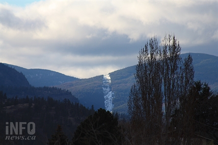
Get ready for a white but 'bone chilling' cold Christmas in Okanagan, Kamloops
It's the first official day of winter tomorrow and the by evening it will look very much like winter with anywhere from five to 10 centimetres of snow falling throughout the Thompson and Okanagan regions into Wednesday. Then get ready for the cold. “This is our real first... push...
 Valandos

It's the first official day of winter tomorrow and the by evening it will look very much like winter with anywhere from five to 10 centimetres of snow falling throughout the Thompson and Okanagan regions into Wednesday.
Then get ready for the cold.
“This is our real first... push of cold Arctic air,” Environment Canada meteorologist Ross MacDonald told iNFOnews.ca. “We’re going to see some bone chilling Arctic air make its way down and it’s going to be very very cold, especially by the time we get to Christmas Eve and Christmas Day.
Lows could get down to -15 Celsius to -20 C. Those are not record setting cold temperatures for December. It would have to get down to -25 C for that to happen.
READ MORE: Coquihalla Highway reopens to essential commercial traffic today
Seasonal averages for daytime highs for this time of year are about -2 C. Looking ahead to the Christmas weekend, those highs are expected to be in -10 C to -12 C range.
Highs are forecast to be around the freezing level Wednesday and gradually drop until the cold air comes in from Siberia.
“We’re going to see that funnel down through the Central Interior,” MacDonald said, noting that area is looking at temperatures of -40 C. “It’s not going to reach the Southern Interior with the same kind of intensity.”
But before that really cold weather hits there’s likely to be even more snow after the Tuesday night and Wednesday morning event.
“We still have mentions of snow and periods of snow but that will be more in the five cm range,” MacDonald said. “It will be that nice light fluffy snow.”
It looks like the Arctic front will linger well into next week, making it chilly for those visiting regional ski hills over the holidays.
Ski hill alpine snow base levels today, Dec. 20:
- 144 cm – Sun Peaks
- 125 cm – Silver Star
- 140 cm – Big White
- 137 cm – Apex
To contact a reporter for this story, email Rob Munro or call 250-808-0143 or email the editor. You can also submit photos, videos or news tips to the newsroom and be entered to win a monthly prize draw.
We welcome your comments and opinions on our stories but play nice. We won't censor or delete comments unless they contain off-topic statements or links, unnecessary vulgarity, false facts, spam or obviously fake profiles. If you have any concerns about what you see in comments, email the editor in the link above.