Extreme cold warnings issues throughout the Southern Interior
As the snow tapers off in valley bottoms, extreme cold and wind are descending on the Southern Interior. That has triggered a number of extreme cold warnings in the region and snowfall warnings on mountain passes. Up to 20 cm of snow could still fall on the Coquihalla Highway between...
 Valandos
0
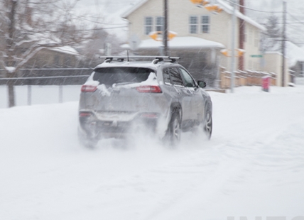
As the snow tapers off in valley bottoms, extreme cold and wind are descending on the Southern Interior.
That has triggered a number of extreme cold warnings in the region and snowfall warnings on mountain passes.
Up to 20 cm of snow could still fall on the Coquihalla Highway between Hope and Merritt until midday today, Jan. 11, according to Environment Canada.
Snow in the Okanagan should also taper off this morning but another 2 cm may still fall. Only flurries are forecast for Kamloops today.
“An extremely cold arctic ridge is building over BC and pushing south,” the extreme cold warnings say. “Temperatures between -25 Celsius to -30 C in combination with winds of 30 km/h gusting to 50 km/h will create dangerous windchill values near -35 beginning this evening.”
Those warnings apply to the Coquihalla Highway from Hope to Kamloops and the Okanagan Connector.
An extreme cold warning has also been issued for the North and South Thompson, North and East Columbia and the East Kootenays through the weekend.
“Temperatures between -25 C to -35 C in combination with periodic winds of 20 to 30 km/h is giving dangerous windchill values of -35 or lower (-40 C),” that warning says.
There are no extreme cold warnings issued for the Okanagan but the Environment Canada online forecast calls for wind chills in the Okanagan of -24 C today, dropping to -33 C overnight with winds gusting to 30 km/h.
An extreme cold warning also applies to Highway 1 through the Rogers Pass.
"Temperatures between -25 C to -30 C in combination with winds of 30 km/h gusting to 50 km/h with create dangerous windchill values near -35 C beginning this evening. Winds will diminish on Friday however temperatures near -30 C will combine with lighter winds to continue extremely cold wind chills. Travellers may also experience episodes of blowing snow that reduce visibilities."
Today’s high temperature is expected to be -9 C in the Okanagan, dropping to -21 C overnight. Friday’s high is expected to reach only -19 C with the overnight low into Saturday morning of -25 C.
Skies are forecast to clear Friday with sunshine on the weekend along with the extreme cold.
Kamloops can expect a high of -14 C today, dropping to -23 C overnight. Friday should be sunny with a high of -20 C and and an overnight low into Saturday morning of -26 C.
Temperatures should moderate slightly starting Sunday. While there is a gradual warming trend into next week, daytime highs are expected to only reach the -7 C to -8 C range by midweek.
To contact a reporter for this story, email Rob Munro
mailto:rmunro@infonews.ca
or call 250-808-0143 or email the editor
mailto:news@infonews.ca
. You can also submit
http://tips@infonews.ca
photos, videos or news tips to the newsroom
mailto:tips@infonews.ca
and be entered to win a monthly prize draw.
We welcome your comments and opinions on our stories but play nice. We won't censor or delete comments unless they contain off-topic statements or links, unnecessary vulgarity, false facts, spam or obviously fake profiles. If you have any concerns about what you see in comments, email the editor in the link above. SUBSCRIBE to our awesome newsletter here
https://infotel.ca/newsletter
.